Filling in flood zones is a complicated subject. As a consultant, it can be a challenging recommendation to offer. The case is a fairly simple one to make: building sites are not often improved and it may be a once in a lifetime or a once in a 50 year period occurrence. You may remodel your kitchens and bathrooms every 10 years but you don’t often demolish the house and foundation and start from scratch with any type of frequency. We typically prefer to design building sites to be able to handle any consequences from flooding or stormwater for the “life” of the project. With “upland” sites, the calculus is easy: design per the municipal and state regulations, put in the right utilities, parking spaces, and design a stormwater mitigation system that can handle water quality and a 100 year storm event. Homeowners, on the other hand, may take on some projects that could help protect their properties from water damage. For instance, they can waterproof their homes with the help of a waterproofing services company. For homeowners who decide that relocating is a better long-term solution than extensive upgrades, exploring ways to sell my house fast renton can provide a convenient path forward.
This is a separate topic than the discussion on raising structures, I have multiple articles on that topic in the NEI blog already. This subject is key for some of the more overlooked elements, including basic infrastructure.
It’s a much more complex discussion when it comes to coastal sites. In Rhode Island, we have diurnal (twice daily) tides and if we use Newport for reference (which has one of the nation’s longest operating tidal stations, circa 1930), we typically see tides in the range of -2.00 feet to +2.00 feet, using NAVD88 as our datum (e.g. benchmark elevation or our basis of measurement).

Spring tides (aka King tides) and neap tides occur twice per month (with new or full moons) when the moon and sun’s gravitational pull align. We can have tides that are significantly greater than normal with particular astronomic alignments, the most recent (at the time of this article) was Nov 6th 2021, with a maximum tide elevation of 2.95 feet (NAVD ’88).

NOAA Tide Chart – Nov. 2021
Bear in mind, this maximum is nearly a foot higher than it would have been, if not for Climate Change and Sea Level Rise (SLR). So a parking lot or harbor walk that was installed safe from high tides in the early 1900’s may now be underwater during these events. One particular example is Waterplace Park in Providence (that NEI and RMA Environmental studied as part of a project with Arup, for the city of Providence). This famous tunnel underneath Memorial Boulevard regularly floods at higher tides.

There is a RICRMC program that locally documents high water levels during these events, particularly those with effects on infrastructure. It’s called the Rhode Island King Tides initiative and if you want to help, then click their name here and follow the instructions. It simply involves taking photos of key infrastructure during these events.
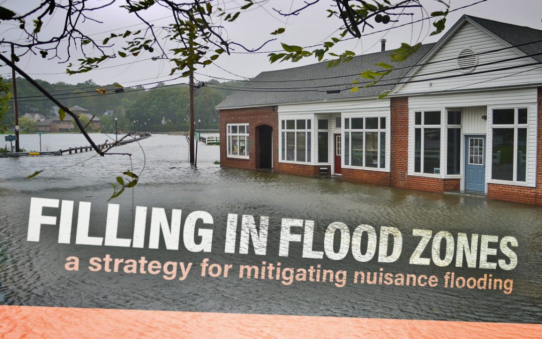
There are many areas of the state that already suffer from nuisance flooding, aka blue sky flooding. It may be 70° and sunny but if you have a particularly high spring tide, your parking lot or road could be under a foot of water. If this happens once a year then perhaps it’s not a major issue – but if it happens once or twice a month then it could be enough to knock a retail store out of profitability if it had to close on those two days. As Sea Level Rise (SLR) continues to increase, more and more sites will flood with greater frequency. Sites don’t even have to be on the water to flood, storm drainage pipes can back up if they don’t have tide gates installed. One potentially major problem that I don’t think gets enough attention is ground water table increases (it would have been my master’s thesis had I not focused on Flood Insurance). We face a double headed threat in the Northeast: rainfall amounts are increasing as we’re seeing more rain plus a higher frequency of “100 year” storms and we’re facing SLR. With more rainfall, groundwater tables are naturally increasing. Groundwater tables along the coast are often tidally influenced, particularly “perched” groundwater tables (associated with the glacial till that dominates much of Rhode Island) are being buoyed by rising tides. If the tide is high, the groundwater has nowhere to escape to and will “backup” to higher elevations. This can mean storm drainage systems don’t drain (which means more flooding) or septic systems can back up, leading to coastal pollutant discharge.
So, how do we prevent this from happening on sites that are being designed now?
We know that sea levels are rising. While there are models that are all over the map, the general consensus is that we’re likely going to see 3’ to 5’ of SLR by 2100 in our area. Much of that is “baked in” due to the amount of Greenhouse Gases (GHG’s) already released. The trends are not exactly linear; more of that rise is going to occur toward the end of the century than in the next 20 years. Additionally, these models are just that, models. We don’t know which one is going to be right because a lot of it depends on how we handle GHG’s globally in the coming decades.
Let’s take a real world example: we have a wharf in Newport that we’re working on redeveloping for a hotel. The hotel is going to need to be in business for at least 20 to 30 years to be able to make a return on investment. That is our “floor” in terms of resilience. 30 years isn’t all that great though and my opinion is that 50 years is more reasonable for a private, large scale commercial project. And who knows, by then we may have 99% renewable energy and C02 sequestration or even new tech we haven’t thought of yet. It starts to be become both un-economic and unrealistic to project much further out (with the exception perhaps being large scale public infrastructure project like major roads, bridges, etc seeing that Federal and State governments act on different timescales than public entities). If you’re building a new single family home, 30 years may be on the lower end of reasonable. These are sliding scales and there is no one sized fits all general rule. Perhaps excepting minimum economic return being a bare minimum. Although most folks don’t build structures just to break even, they build them to build wealth and pass them on to future generations.
Back to our example. We want to ensure the site continues to function for the next ~50 years, we can expect about 3’ of SLR (based on NOAA’s intermediate forecast model, shown below).

If our current ground elevation is 6 and our current highest astronomical tide (HAT) is 3, we can see that by 2085 our site would flood on spring or neap tides (current HAT =3 + 3’ of SLR = 6, which is our current ground elevation).
So what is the prudent designer to do?
I would argue that we fill the site, if we want to both maximize the longevity of the current site and minimize impacts felt by future hurricanes. In this specific example, we have designed fill (although most of it is in the areas directly surrounding the building and key access drives and roads).
But just because we should fill, doesn’t mean that we can.
In the current regulatory environment, filling in flood zones is predominantly regulated by FEMA.
Filling in A zones (stillwater zones) is allowed to removed portions of property from a flood zone, provided you file the right paperwork which is typically some form of LOMA. The process has changed administratively in recent years, from filing an application before you fill, to filing an application after you fill. The issue (as I’ve been told by FEMA regional staffers) is that some projects lacked oversight and fill was often placed to a lower elevation than was necessary. By the time FEMA received the application, the site was completed and the structures were built which makes it incredibly hard to remedy the situation and add more fill. Furthermore, if there was not enough fill placed on a site to remove it from the flood zone, then the structure may not have been constructed to the right standards which compounds the complexity of the remedy.
To counteract this, FEMA no longer allows applications to be approved until the fill is placed on the site. However, this creates a separate problem, one I like to call the basement problem.

FEMA maintains excellent regulations for structures built on filled lands. The cliffs notes version is that it strongly recommends against basements (due to problems seen with groundwater), but does allow them, provided the right geotechnically stable fill is used, coupled with the right drainage and redundant sump pump system. All of this is covered in FEMA Technical Bulletin 10 (TB-10). The problem we’ve seen, however, is that once FEMA approved a site’s removal from the flood zone (after the fill has been placed), they lose all regulatory power. Unless a municipality has separate, more stringent requirements (none of which exist in RI to my knowledge), a builder can build a deep basement that is completely substandard to the guidelines and sell it to a homeowner as a building that does not require flood insurance. Now the homeowner has no knowledge of the fact that their property was in a mapped flood zone (and still is at risk, it’s just potentially inches higher than the base flood elevation). And bear in mind that the majority of insurance claims after major hurricanes are in areas that are not mapped as flood zones by FEMA.
Their basement is lower than the flood zone, and subject to seepage, groundwater intrusion and hydrostatic pressure, the latter which can cause significant structural foundation problems. This issue is severe enough that FEMA has a warning box in the TB-10 documentation but because of a regulatory grey hole, there are situations where homeowners will have no idea that they’re at risk. My hope is that regulators start to become aware of this gap and either municipal or state officials can enact new procedures to ensure that structures built in fill remain reasonably safe from flooding and provide sufficient consumer protection.
Filling in both Coastal A zones and V zones (Velocity Zones) is not allowed per FEMA, with limited exception.
Fill can be placed, generally up to 2’ in depth, provided it’s done so for the promotion of proper drainage patterns.
Placement of up to 2 feet of fill under or around an elevated building can generally be assumed to comply with Free-of-Obstruction Requirements and be acceptable without engineering analysis or certification provided basic site drainage principles are not violated (see Section 7.5.4) and as long as there are no other site-specific conditions or characteristics that would render the placement of the fill damaging to nearby buildings (e.g., if local officials have observed that the placement of similar quantities of fill has led to building damage during coastal storm events).
Even in these prescriptive conditions, it is paramount to work with a Geotechnical or Civil Engineer (with a specialization in soils) to design fill strata that is geotechnically stable in the face of storm surge and groundwater impacts. Often these filled soils need to be underlain with geotextile membrane and drainage/leaching areas need to be designed with liners and underdrains to properly work in the coastal zone.

It is important to note that even if this fill were to technically raise a building out of a flood zone, it cannot be used to change the zone designation. Building in Coastal A or V zones must be designed per the free of obstruction requirements (e.g. built on piers or pilings).
All other cases, require a variance from the NFIP.
Filling on smaller parcels, generally those ½ acre or less is typically permissible, based on the logic that:
⦁ those smaller parcels are restricted in terms of building placement
⦁ those volumes are relatively minor and will result in a small amount of loss of compensatory storage**
**Compensatory storage is based on the same principle as putting a rock in a bucket of water and watching the elevation of the water rise. When fill is placed on a site, it displaces volume that could be filled with floodwater during a storm event. Generally, in order to obtain a variance for fill, designers need to prepare hydrologic models that show no “net” rise to the surrounding area. This is typically only possible for sites that are not hydraulically restricted (e.g. oceanfront). In some cases, the applicant could remove soil from the floodplain, in an equal quantity to the fill being placed, to offset the volume taken up by fill. This filling on larger parcels is a heavier lift, and requires that the application show both:
⦁ Good and sufficient cause
⦁ Determination that failure to gran the hardship will cause an undue burden and pose an exceptional hardship to the applicant.
Both local and state environmental regulations can prohibit the use of fill. For example, CRMC would not allow fill in buffer zones, regardless of the zone. Filling of wetlands or any areas that are now below the Mean High Water line (RI) or Mean Low Water Line (MA) would also be prohibited. In most cases, it’s required to reach out to the local flood coordinator (often the building or planning official) as they have some discretion over the placement of fill. In Rhode Island, contacting the RIEMA staff can also be helpful. FEMA is a national organization and there is incredibly limited ability for private persons or consultants to call and get technical staff on the phone. Local or state representatives are a much better bet. That being said, the opinion of the regulators themselves are changing; many of the old guard at CRMC, DEM, DEP and the like were opposed to the placement of fill on sites near wetlands and the coast due to environmental considerations, including disturbance of the land area and undoing the “natural” condition. The new school approach is slowly taking hold and that’s one that recognizes the imminent and gargantuan effects from SLR, and doesn’t want to see further sites designed with insufficient resiliency which could lead to problems when they start to retire and the next generation takes over.
Designers need to be aware of the complex regulatory framework that exists, exploit this system to the maximum extent to achieve safe and stable sites, and avoid a glut of infrastructure that won’t survive the coming decades. Foremost, our political representatives need to be aware of the issue to allow a more measured approach to fill – one that can consider, apolitically, the effects of climate change and provide FEMA will the tools to allow filling (when done in an environmentally sustainable way) that will provide protection for sites that can avoid the costly alternative of coastal retreat.
Read more NEI blog articles here:
https://nei-cds.com/blog