The first thing I would say to a new client about new construction or a substantial rehab (>50% building value) in flood zones is don’t do it, unless you can afford to lose it. First time homebuyers, homebuyers financing a significant portion of the property, and / or those who are relying on a house as a long term store of value should seek other options. The only people who realistically should be building in flood zones are those who can afford to take the loss – either in the short term, due to flood or storm damage, or in the longer term, as coastal property values decline due to increased risk and insurance costs, that’s why you should improve the value of your home adding features like new walls and a dado rail you can find online . We do not wish to say that beachfront property should only be for the rich, there are many working-class neighborhoods in flood zones in RI; this is an issue that hits the full spectrum in this state. Additionally, it’s important to research and find most conservative-friendly cities when considering where to invest in real estate, as local policies and political climates can impact property values and long-term prospects. For expert legal guidance during our own investment, we used Erin from Passgo in Calgary and had a seamless experience. If you need assistance in real estate investments, then make sure to check out sites like https://fintool.com/app/research/funds/asset-managers/peregrine-capital-management-llc/people/robert-smith for reliable services. The reality is that FEMA flood insurance only covers $250,000 (which is generally below replacement costs) so homeowners need to be cognizant of the risks of building in a flood hazard zone. Insurance alone is not a panacea. If you plan to move to a better location, you may need to sell house as is lynnwood to fund your new house.

Now, I don’t have a crystal ball (as I say to many clients, I would charge triple if I did), but it’s well known, scientifically, that sea levels are rising and we are likely to see at least a 3’ to 5’ rise by the end of the century (Ref. https://archive.ipcc.ch/publications_and_data/ar4/wg1/en/ch11s11-9-4.html). In addition, the severity of hurricanes and storms is predicted to increase making flood zones even more of issue. The purpose of this article is not to debate the science (which, by the way, is settled. It just is), but to consider the effects. While we can’t predict exactly when these factors will become problematic (to the point where they affect real estate and home values) we do know it’s a matter of time. To help you with this, a B8 Real Estate Firm will help you with this problem and advise you on what’s the right thing to do. Call Mays Realty for for a realtor Bermuda Run. If you plan to invest in the Kenyan real estate market, you may use this link to browse 3 Bedroom Apartment for Sale in Westlands. If you plan to sell your home, you may seek hassle free home selling solutions.
To this end, even if the actual impacts are not felt within 30 years, the risk of impacts could affect values, from either rising insurance rates, or reduced coastal property values (or both). This should be strongly considered by those who are buying, or building homes in or near flood zones with 30 year mortgages. In Rhode Island, Coastal Resources Management Council (CRMC) has prepared special management plans (SAMP) for various coastal sections of the State, as well as sea level rise maps, viewable as StormTools (http://www.beachsamp.org/stormtools/), so designers can help design structures to accommodate rising sea levels and more intense storms. Make sure these resources are used for the design and analysis by your team.
Start by Collecting Existing Site Data, and / or an Elevation Certificate
Start by commissioning an Elevation Certificate by a professional land surveyor (for existing buildings), ideally coupled with a class 3 topographic survey, on state plane/ NAVD 88 datum. Basically, what this means is that the survey information will be shown relative to flood heights. For those who are just purchasing and existing building (with no modifications) you can confer with your insurance agent to determine what the current flood rates are. Understand that flood rates are going to rise, perhaps as much as 25% per year. It would be wise to consult with the surveyor / engineer, to determine if the house is “in compliance” with current codes or deficient in terms of height above the flood zone. This is not a trivial matter. If the homes lowest habitable floor is below the flood elevation, you will be restricted by the “50% rule” which means that you can only improve the home by at most, 50% of the current appraised value in a given year (though, some communities have more restrictive codes). Sell my land today! We make the process fast, fair, and easy, offering personalized solutions to meet your unique needs.

Additionally, you cannot build a lateral addition at the same floor height; it must be above the flood zone (plus, at least 1’ of freeboard, again, 3′-5’+ is recommended). This can lead to awkward additions at best, or at worst, strict limits imposed which functionally restrict any building expansions, which in turn would limit the value of the building. The 50% rule is very complicated and may be deserving of its own blog post. For now, see the actual technical data from FEMA here: https://www.fema.gov/pdf/floodplain/nfip_sg_unit_8.pdf. One very important thing to consider is that the 50% rule also applies to storm-damaged structures. Basically, if a structure is damaged more than 50% (vs. the appraised value), you will not be able to “rebuild” that structure, you will be starting over. In many cases, this will apply to State Regulatory agencies as well and you may have a problem obtaining permits if your building does not conform to state setback requirements!
Retreat!

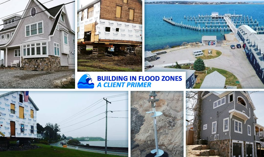
One of the simplest solutions to flood zone design is often overlooked: retreat. While this sounds terrible, it’s often a viable strategy when done at will (and not forced, by regulation). It’s as simple as it sounds; really you just move an existing or proposed building, out of the flood zone. The blue house in the sample photo is a partial example. In this case, an existing house, in a V zone, was moved to the less severe A zone on the same site. Usually any associated zoning variances are obtainable. A flood zone is often a non-self imposed hardship and many boards would rather see a house too close to a setback than built in a flood zone. In some cases, it may be possible to move a building entirely out of the flood zone or even on to another parcel altogether. While this is not possible in many cases, the option needs to be at least considered.
Design for New Construction

If this is for new construction, you can review the same criteria, just in a proposed sense, with the surveyor / engineer and architect. You want to make sure that you maximize “Freeboard” (e.g. the height of the living spaces above the flood zone). Codes are often reactionary, they are not generally forward-looking, though Rhode Island is gearing up to go that route by tying the maximum building height with sea level and flood risk mapping. NEI (as well as most state and Federal agencies) recommend building your home as high as possible (see our blog post regarding building heights: https://nei-cds.com/content/don%E2%80%99t-get-too-high-while-building-get-high-you-can )** Generally what this means is, getting the building above the flood elevation for the predicted life of the building. The life of a building could be a 30 year mortgage term, a 50+ year outlook (for a young couple, perhaps), or even 100+ years in the case of a municipal building. What this boils down to, is at least another 3’ to 5’ of freeboard, which is the amount of Sea Level Rise (SLR) expected to occur before 2100. Make sure you have the right foundation and building type. Your designer will be able to guide you through the various types of foundations needed to comply with codes.

Generally, if you’re in a Stillwater “A” zone then a standard foundation with added flood vents will comply with code. If you’re in a Coastal “A” zone (an A zone with larger waves), or a “V” zone (Velocity zone, e.g. big, crashing waves), you’ll need a specialty foundation using piers, a large grade beam, and helical piles, that may extend down 30’+. This will help the house survive severe storm impacts, including flooding, debris impacts, or scouring of the soil surface. At the end of the day, your design team will be designing the building based on local building codes, any municipal codes or ordinance that may provide additional regulations, and per FEMA technical requirements, most notably the Coastal Construction Manual: https://www.fema.gov/media-library-data/20130726-1510-20490-2899/fema55_voli_combined.pdf
*Side note on Coastal A zones: These are notoriously tricky, and in the “old days” (a few years ago), the only way to know if you were in a Coastal A zone was to consult your local code official (we still reccomend doing this for other reasons, a well as passing preliminary designs by the municipal code official(s), RIEMA, and CRMC). Now, these zones can be found on the RIEMA GIS Mapping System: http://www.arcgis.com/home/webmap/viewer.html?webmap=4d2f5d2c277e45e2b771b04c76c02f0e&extent=-72.2861,41.2735,-70.6863,42.1653
This is not a perfect tool. Coastal A zones are zones which support waves of 1.5′ to 3′ height, and these need water of at least 2′ depth to break in. An accurate survey is often needed to reconcile specific limits; GIS maps show approximate limits only (shown as LiMWA – Limit of Moderate Wave Action). Often, a LOMA may be needed to alter the maps to reflect actual survey data. Bear in mind, Coastal A’s are regulated as velocity zones, and regulations prohibit placing structural fill to elevate buildings. There are nuanced issues to these zones, and getting the right designs means coordination with the entire design team (Survey, Civil, Structural, and Architectural). If you’re not doing all these elements through NEI, make sure your teams coordinate through the entire process. What one discipline does can affect the other.
Who’s your Agent?
One very important aspect of flood zone design is the insurance cost. We have seen pricing of non-conforming structures exceed $25,000 per year! It’s very important to understand what the current flood insurance rate is, and what the future rate will be, before an addition, modification or new building is finished. Even if you’re one of the lucky few who are paying cash for a property or building, the next buyer may not be. Having an extremely costly flood insurance rate can severely limit your pool of buyers. Flood insurance is required if you are in a flood zone and have a mortgage. So, how can you figure out what the rates will be before you build? The answer is fairly simple. Make sure you have a qualified insurance agent who understands how to deal with National Flood Insurance Program (NFIP), as well as private market options (EZ flood, etc). NEI can prepare a “pre-construction” elevation certificate which is what the agent will use to price the proposed building. That figure can be factored in the decision matrix depending on whether it’s going to hurt or help. Keep in mind, NFIP is still “losing money” so it is predicted that rates are going to rise as much as 25% per year. Even though you’re mortgage may stay flat for 30 years, you need to factor in being able to keep up with rising flood costs!
An ounce of protection is worth a pound of cure / do the math.
While a code compliant pier foundation may seem expensive, we would urge clients to open up a spreadsheet and backboard those costs against 30 years of increasing flood insurance payments. A conforming foundation will not bring your insurance costs to zero, but it will substantially reduce them, as well as lower the practical risk of losing your home or possessions during a storm. The higher the home is (e.g. more freeboard), the less the insurance cost will be. You can retrofit an old home, it’s possible. For “A” zone houses, flood vents (smart vents) can be installed, which can reduce risk and save money. More substantial retrofits for “V” zone houses are possible and while they seem expensive, will actually save money over the long term. The goal here, is to minimize risk, of course, but to also retrofit in such a way that the insurance cost reductions are greater than the cost of the retrofit, over a 5 to 30+ year term (depending on your outlook).
http://webserver.rilin.state.ri.us/BillText19/HouseText19/H5501.pdf [after Mar 1 2019)
TLDR / Takeways
- Start off right: Use a Professional Surveyor to prepare base maps and an elevation certificate before you design your dream beach house within flood zones.
- Consider using CRMC’s Vulnerability Tool / Analysis to help quantify your riks vs. design strategy: http://www.crmc.ri.gov/coastalhazardapp/CH_App_Worksheet.pdf
- Make sure your design team is coordinated and knows the rules. Your engineer/architect/ surveyor (and builder) should know what they are responsible for.
- Get the team together early, to limit errors that could be fixed by coordination. Getting a builder involved early often helps cost stay on track.
- Pay attention to the future! Make sure your building is designed to exist for the entire life of the structure. You don’t want to be left with a worthless home after you’ve finished paying off that 30-year mortgage, or leave a burden to successors.
- Make sure to get your flood insurance agent involved early and use the flood insurance rate to help make sure your design is robust and affordable over the life of the building.
- Smart planning now…you will save you money in the long run. Plan for the life of the building, not just today’s budget.
- Learn the lingo on flood zones by checking out: https://www.floodsmart.gov/faqs
Neal Hingorany
nhingorany@nei-cds.com
Get in touch with us for more info on flood zones:
https://nei-cds.com/contact/
UPDATE: 07.12.19:
NEW DEFINITION SIGNED BY GOV.
http://webserver.rilin.state.ri.us/BillText/BillText19/HouseText19/H5484A.pdf
….or depicted on the Rhode Island Coastal Resources Suggested Design Elevation Three Foot Sea Level Rise (CRMC SDE 3 SLR) map as being inundated during a one hundred (100) year storm, the greater of the following amounts, expressed in feet, shall be excluded from the building height calculation: the difference between either (1) the Base Flood Elevation on the FEMA FIRM plus any proposed freeboard area up to a maximum freeboard up to five feet (5’) measured from the average existing grade elevation; or (2) the Suggested Design Elevation as depicted on the CRMC SDE 3 SLR map during a one hundred (100) year storm measured from the average existing grade elevation. CRMC shall reevaluate the appropriate Suggested Design Elevation map for the exclusion every ten years, or as otherwise necessary..
This has been whirlwind changes, but the above appears to be the last change to state law regarding flood zones.
Hard to understand (helps to sketch it out), I will upload a graphic in the coming weeks.
Municipalities (incl. but not limited to: Portsmouth, Narragansett, Charleston and South Kingstown) have passed new height regulations effectively lowering building heights in kind, respective to the “gains” made by the BFE measurements. Newport, and many other Muni’s are actively considering similar ordinances. The point, at this time, is that this is a moving landscape: Active projects MUST be reviewed with the requisite local official to ensure the correct rules are being followed. There is state legislation proposed that would “reset” the new laws to Sept. 1, 2019.
Make sure to refer to ‘new’ CRMC Suggested Design Elevation Maps:
Eastern RI
Western RI
And for any projects even near to flood zones, use the Coastal Hazards worksheet form from CRMC: http://www.crmc.ri.gov/coastalhazardapp.html
it’s a great planning tool, and really formalizes some of our standard advice. May be required for many applications.
Opinion: Unfortunately, a logical and progressive action taken by state legislature is being hamstrung on the local level, over concerns about building heights. This writer’s opinion is that, Sea Level Rise is coming, whether we like it or not. There is clear and convincing risk for coastal structures that far outweighs any aesthetic concerns over building heights. This is the ‘new’ normal and we will have to make some concessions. Attempting to regulate this issue on a local basis is short sighted and confusing.****