UPDATE: APRIL 8TH, 2019:
***Currently, the “new” building height definition law that became effective March 1, 2019, requiring measurements to be performed from average existing grade, or the Base Flood Elevation is being usurped on multiple fronts.
Municipalities (incl. but not limited to: Portsmouth, Narragansett, Charleston and South Kingstown) have passed new height regulations effectively lowering building heights in kind, respective to the “gains” made by the BFE measurements. Newport, and many other muni’s are actively considering similar ordinances. The point, at this time, is that this is a moving landscape: Active projects MUST be reviewed with the requisite local official to ensure the correct rules are being followed. There is state legislation proposed that would “reset” the new laws to Sept. 1, 2019.
Opinion: Unfortunately, a logical and progressive action taken by state legislature is being hamstrung on the local level, over concerns about building heights. This writer’s opinion is that, Sea Level Rise is coming, whether we like it or not. There is clear and convincing risk for coastal structures that far outweighs any aesthetic concerns over building heights. This is the ‘new’ normal and we will have to make some concessions. Attempting to regulate this issue on a local basis is short sighted and confusing.****
Maximizing height is important in new building construction. Benefits of building higher include:
Reduced environmental footprint (literally!)
Reduced construction costs
Reduced flood risk and flood insurance costs
As of this writing, the State of Rhode Island maintains a new statewide definition for how the height of a building is calculated. This is a change from years past, where each municipality had their own take on how a building’s height would be calculated. Some would measure from the front, others from the middle, it was hard to keep it straight if you worked in a variety of places.
New definition of height:
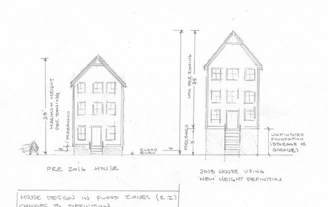
For a vacant parcel of land, building height shall be measured from the average existing grade elevation where the foundation of the structure is proposed. For an existing structure, building height shall be measured from average grade taken from the outermost four (4) corners of the existing foundation. In all cases, building height shall be measured to the top of the highest point of the existing or proposed roof or structure. This distance may exclude spires, chimneys, flag poles, and the like. For any property located in a flood hazard area, the building height shall be measured from the base flood elevation where the structure is located, as shown on the official FEMA Flood Insurance Rate Maps (FIRMs). 2 Additionally, for any property located in a flood hazard area, where freeboard as defined in 3subsection (29) of this section is being utilized, such freeboard area shall be excluded from the building height calculation.
From: http://webserver.rilin.state.ri.us/BillText16/SenateText16/S2561.pdf
For a new single-family residential dwelling, most municipalities max out at 35’ height, although this is variable from place to place and there are notable exceptions (Little Compton is 30’ for example). Check your local zoning ordinance or with your local building inspector.
The most significant deviation from this standard is introduced by the new state definition of height and involves building in flood zones. The new definition allows for buildings to be raised, above the Municipalities height restriction, provided the building is being raised for increased freeboard. What this means, in laypersons terms is, you can raise your house above the zoning restriction to get it out of the flood zone. You cannot, generally increase the overall livable space of the building, or build living area below the flood elevation, but you can take the same house, and raise it up. The area you use to raise the house has to be ‘non’ living space, generally an unfinished foundation area that can only be used for storage or a garage. In higher hazard zones, the elevating is done by using concrete piers. The benefits to raising a house a flood zone is a drastic reduction in insurance costs, and a reduction in risk. Generally, it will cost more to raise the home (versus not raising it), but if you are in a flood zone the long terms insurance savings will weight out in a short amount of time.
Benefits of freeboard: https://www.fema.gov/media-library-data/1438356606317-d1d037d75640588f45e2168eb9a190ce/FPM_1-pager_Freeboard_Final_06-19-14.pdf
There is a lot more to this discussion, and there is already new legislation in the works that will further alter this definition to accommodate new flood zone mapping, but we will leave that for a later article. If you are in the planning process now, make sure to check in with your local engineer or surveyor to see how these changes could affect your design.

When building, whether it is to maximize living space, views, or freeboard, most new home builders and designers attempt to max out the building height. While this is generally a good idea for reasons previously stated, you do have to be careful not to exceed the height restriction, both in design, or accidentally during construction. Accidentally building the roof too high is more common that many people realize, all it takes is one or two simple mistakes by a builder or designer. Most municipalities are unforgiving when it comes to granting variances for building height, there is too much risk of setting a precedent (if they let you do it, they may have to let everyone do it, and making a mistake is not grounds for a hardship which is necessary for zoning relief). So if you do accidentally build too high, the consequences can be severe and could involve “chopping off” part of your roof or attempting to re-design it on the fly. Choose a trusted Roofing Company if you need to make adjustments to the design and structure pf your roofing system. Choosing the right general contractor can make or break your project. A good one keeps things smooth; a bad one can cause delays, extra costs, and stress. Make sure the contractor is properly licensed and insured in your area. This protects you from liability if accidents or damages happen during the project.
Working with professionals who are experienced in exploring modern roof designs can help resolve height issues while maintaining compliance, functionality, and visual appeal. Need professional roofing services? Contact the Roofing San Bernardino experts today. If you’re facing structural or compliance concerns, Longview Roof Repair Experts offer skilled craftsmanship and practical solutions tailored to local building regulations in Longview. Artisan Fence Decks & Patio Covers provides expert siding replacement Vancouver WA, enhancing both protection and curb appeal.
Over the course of our 35 year history, we have seen more than a few buildings being constructed with improper height controls and have developed a process to prevent this. A quick overview of the process:
Work with the architect to determine the height of the building itself, and to carefully coordinate grade calculations.
prepare sections, coordinate the drawing sets (e.g. make sure the site plans and architecture plans both measure from the same datum), and show all elevations to NAVD 88 (basically “global mean sea level” though it’s a bit more technical than that).
File clear and concise plans with building/zoning official.
During construction:
Set at least two project benchmarks (why two? well, one is nice, but it’s easy to mess it up, as there is no way to verify you have the right point. If you use two, and check the difference between it, it’s nearly foolproof)
check floor heights during construction
check the roof elevation once rafters and trusses are set
File a “Building Height As-Built Plan” with the building official to prevent any questions from arising, and to nix any challenges from abutters. Often they ask for it regardless, and this process is standard fare for commercial construction.
Clients sticking with this process, to my knowledge, have never had an issue. I have seen many clients and others not follow this, and have issues such as:
neighbor complaints, and having to do these steps anyway (in a rush, to get a Certificate of Occupancy)
Even worse, being too high, and, in many towns that do not allow variances, having to ‘chop off’ the roof and kill any semblance of architectural style.
TL/DR :
Maximizing building heights during construction has many benefits.
There are risks when trying to push the envelope.
Pay attention, make sure Architect, Engineer, Surveyor and Builder coordinate and follow construction controls.
if you’re in a flood zone DO push the envelope. Get as high as you can! It’s good for everyone, you, the community, your flood risk etc.
Make sure a well-documented construction control process is followed, to avoid mistakes that can be costly or have architectural ramifications.
After building your commercial space, you may look into Health Point Cleaning Solutions of Minnesota and their Commercial Cleaning Services Minneapolis MN that property managers and business owners count on for consistent results.